
Add location data to your spectrum analysis indoors
Keysight Technologies has instruments for measuring just about anything you can think of:
- Measuring radio signals, noise and interference
- Gas detection and analysis
- Temperature monitoring
- Infrared scanning
- Vibration monitoring
- Measuring light, noise, humidity, dust, pressure, airflow
Now, wouldn't it be great if you could put your Keysight instruments on wheels - on a smart cart that tracks its location as you walk around a building? We think so. That's why SkyMark has introduced the TRAILMAPPER™ system that combines a location-tracking cart, navigation software, and software interfaces to Keysight instruments.
Indoors, underground or in heavily shielded environments GPS and other location tracking systems aren't available, or may require too much infrastructure. This alternative - the TrailMapper™ location-sensing cart - doesn't. All you need is a floor plan.
How does the TrailMapper™ system help you?
You can add a whole new dimension to your data. Know exactly:
- What your instruments detected.
- When they detected it.
- Where the instrument was located at that very moment.
Why is that good? You can easily plot where you have strong and weak signals, and where interference is a problem, where you have heat losses, or pollutants. You can pinpoint those problems and solve them. Faster.
Example: The TrailMapper™ system can be interfaced to a wide range of Keysight instrumentation. For surveying a wireless network an Keysight N9340A/B or N9342C handheld spectrum analyzer is mounted on the cart and connected, via a bi-directional interface, to a laptop computer running the TrailMapper™ software. The interface allows the laptop to configure the analyzer directly or alternatively to read in the settings from the analyzer. The analyzer can be configured to make continuous RF sweeps, and as the measurements are made, the sweep data is time stamped and stored with the location data. This allows a complete profile of the wireless network to be captured. The data can be viewed on the floor plan in real time with color codes set for different threshold levels.
With the TrailMapper™ system from SkyMark, you now have a viable and practical alternative for adding location-specific data to your critical environmental measurements.
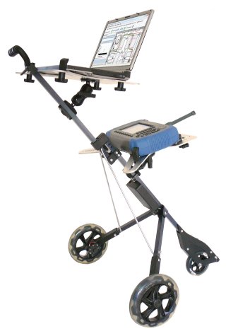
The TrailMapper™ System can be interfaced to a wide variety of Keysight instrumentation. In this case an additional rack is used to mount an Keysight N9340B Spectrum Analyzer.
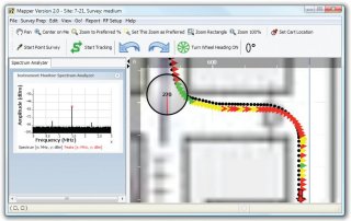
The path traveled by the cart is traced on the plan of a coal mine, in SkyMark's TrailMapper™ software. Signal strengths are shown in color coding.
![]()
For more information on Keysight Technologies' products, applications
or services, please contact your local
Keysight office. The complete list is
available at: www.keysight.com/find/contactus.

SkyMark is a software company based in Pittsburgh, Pennsylvania which focuses on creating software tools that help people improve the way they work.
Useful Links
2024 © SkyMark Corporation. All Rights Reserved.